
Tamacine topographic map
Interactive map
Click on the map to display elevation.
About this map
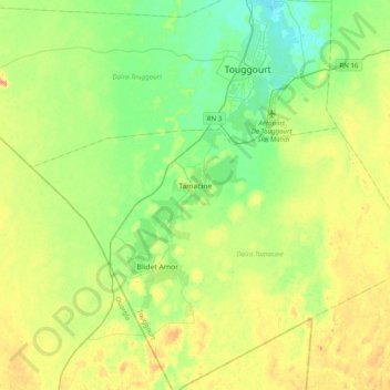
Name: Tamacine topographic map, elevation, terrain.
Location: Tamacine, Tamacine District, Touggourt, Algeria (32.94535 5.84629 33.05991 6.24195)
Average elevation: 88 m
Minimum elevation: 58 m
Maximum elevation: 143 m
Tamacine lies at an elevation of 82 metres (269 ft) within the system of oases near Touggourt. These oases feature extensive palm groves and other agriculture. Beyond this is the arid and barren landscape of the Sahara, featuring areas of sand dunes (ergs) and flat rocky plains (regs). Lake Tamacine, a small lake covering 2 hectares (4.9 acres) and 402 metres (440 yd) long, lies along the eastern side of the town, and is notable for its variety of birds and fish.
Other topographic maps
Click on a map to view its topography, its elevation and its terrain.
Blidet Amor
Algeria > Touggourt > Tamacine District > Blidet Amor
Blidet Amor, Tamacine District, Touggourt, Algeria
Average elevation: 94 m