
Make a donation
Gear up for your next adventure:
As an Amazon Associate, this site earns from qualifying purchases at no extra cost to you.
Saint-Benoît topographic map
Click on the map to display elevation.
Make a donation
Gear up for your next adventure:
As an Amazon Associate, this site earns from qualifying purchases at no extra cost to you.
Saint-Benoît
La commune de Saint-Benoît est composée d'un village principal (Saint-Benoît) et de plusieurs hameaux disséminés entre le Rhône et la montagne, dont le sommet principal (la Grayes) élève à 781 m d'altitude sa noire chevelure de sapins. La commune se situe dans la zone d'appellation contrôlée des vins du Bugey.
Make a donation
Gear up for your next adventure:
As an Amazon Associate, this site earns from qualifying purchases at no extra cost to you.
About this map
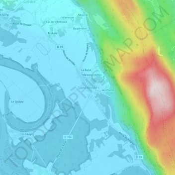
Name: Saint-Benoît topographic map, elevation, terrain.
Average elevation: 316 m
Minimum elevation: 203 m
Maximum elevation: 774 m
Make a donation
Gear up for your next adventure:
As an Amazon Associate, this site earns from qualifying purchases at no extra cost to you.
Other topographic maps
Click on a map to view its topography, its elevation and its terrain.