
Thank you for supporting this site ❤️
Make a donation
Make a donation
Gear up for your next adventure:
As an Amazon Associate, this site earns from qualifying purchases at no extra cost to you.
Lushui topographic map
Click on the map to display elevation.
Thank you for supporting this site ❤️
Make a donation
Make a donation
Gear up for your next adventure:
As an Amazon Associate, this site earns from qualifying purchases at no extra cost to you.
About this map
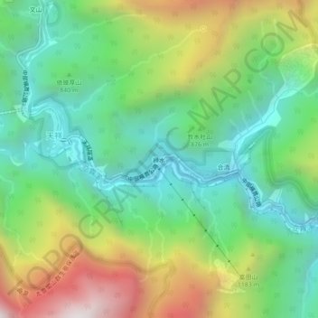
Name: Lushui topographic map, elevation, terrain.
Location: Lushui, Fushi Village, Xiulin, Hualien County, 972, Taiwan (24.15941 121.48840 24.19941 121.52840)
Average elevation: 889 m
Minimum elevation: 347 m
Maximum elevation: 1,893 m
Thank you for supporting this site ❤️
Make a donation
Make a donation
Gear up for your next adventure:
As an Amazon Associate, this site earns from qualifying purchases at no extra cost to you.