
Texaco Town topographic map
Interactive map
Click on the map to display elevation.
About this map
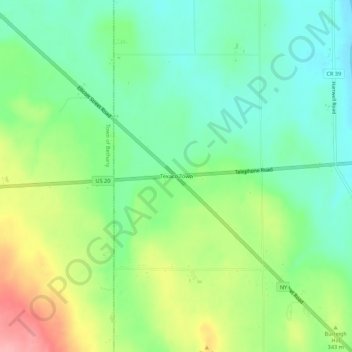
Name: Texaco Town topographic map, elevation, terrain.
Average elevation: 324 m
Minimum elevation: 281 m
Maximum elevation: 402 m
Other topographic maps
Click on a map to view its topography, its elevation and its terrain.
Junction
United States > New York > Genesee County > Town of Pavilion
Junction, Town of Pavilion, Genesee County, New York, United States
Average elevation: 290 m
Bennetts Corners
United States > New York > Genesee County > Town of Pavilion
Bennetts Corners, Town of Pavilion, Genesee County, New York, United States
Average elevation: 338 m
Pavilion Center
United States > New York > Genesee County > Town of Pavilion
Pavilion Center, Town of Pavilion, Genesee County, New York, 14525, United States
Average elevation: 301 m
Union Corners
United States > New York > Genesee County > Town of Pavilion
Union Corners, Town of Pavilion, Genesee County, New York, 14525, United States
Average elevation: 317 m
Phelps Corners
United States > New York > Genesee County > Town of Pavilion
Phelps Corners, Town of Pavilion, Genesee County, New York, 14525, United States
Average elevation: 339 m