
Langenfeld (Rheinland) topographic map
Interactive map
Click on the map to display elevation.
About this map
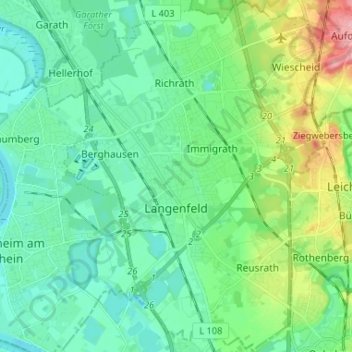
Name: Langenfeld (Rheinland) topographic map, elevation, terrain.
Average elevation: 55 m
Minimum elevation: 30 m
Maximum elevation: 128 m
Other topographic maps
Click on a map to view its topography, its elevation and its terrain.
Abtsküche / Haus Hetterscheidt
Germany > North Rhine-Westphalia > Kreis Mettmann > Heiligenhaus > Tüschen
Average elevation: 168 m