
Croix de Provence topographic map
Interactive map
Click on the map to display elevation.
About this map
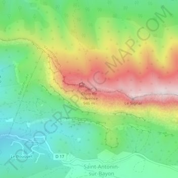
Name: Croix de Provence topographic map, elevation, terrain.
Average elevation: 555 m
Minimum elevation: 288 m
Maximum elevation: 977 m
Other topographic maps
Click on a map to view its topography, its elevation and its terrain.
Montagne Sainte-Victoire
France > Provence-Alpes-Côte d'Azur > Bouches-du-Rhône > Vauvenargues
Montagne Sainte-Victoire, Vauvenargues, Aix-en-Provence, Bouches-du-Rhône, Provence-Alpes-Côte d'Azur, France métropolitaine, 13126, France
Average elevation: 451 m
Col de Portes
France > Provence-Alpes-Côte d'Azur > Bouches-du-Rhône > Vauvenargues
Col de Portes, D 10, Vauvenargues, Aix-en-Provence, Bouches-du-Rhône, Provence-Alpes-Côte d'Azur, France métropolitaine, 13126, France
Average elevation: 663 m