Geolocate

Foral topographic map

Interactive map

Click on the map to display elevation.

About this map

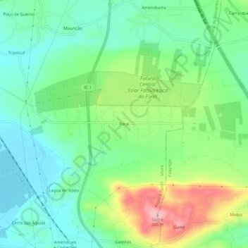
Name: Foral topographic map, elevation, terrain.

Location: Foral, Algoz e Tunes, Silves, Faro, 8365-091, Portugal (37.17330 -8.27405 37.21330 -8.23405)

Average elevation: 93 m

Minimum elevation: 39 m

Maximum elevation: 205 m

Other topographic maps

Click on a map to view its topography, its elevation and its terrain.

Várzeas do Poço da Figueira

Portugal > Faro > Algoz e Tunes > Tunes

Várzeas do Poço da Figueira, Tunes, Algoz e Tunes, Silves, Faro, 8365-235, Portugal

Average elevation: 79 m