Geolocate

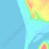
Devbag topographic map

Click on the map to display elevation.

About this map

Name: Devbag topographic map, elevation, terrain.

Location: Devbag, Malvan Taluka, Sindhudurg, Maharashtra, 416523, India (15.95936 73.47523 15.99936 73.51523)

Average elevation: 16 m

Minimum elevation: -2 m

Maximum elevation: 160 m

Other topographic maps

Click on a map to view its topography, its elevation and its terrain.
Dikwal

India > Maharashtra > Malvan Taluka

Average elevation: 103 m

Tarkarli beach

India > Maharashtra > Malvan Taluka > Tarkarli

Average elevation: 11 m

Gear up for your next adventure:

🚲Bikepacking Frame Bags - Storage for tools and navigation gear on long off-road rides
🧢Hiking Hats - Sun and weather protection for outdoor walks
👟Waterproof Leg Gaiters - Keep mud and water out of your boots in boggy terrain
🧥Packable Down Jackets - Lightweight warmth that compresses small in your bag
🥾Trekking Poles - Poles to improve stability on uneven terrain

As an Amazon Associate, this site earns from qualifying purchases at no extra cost to you.