Geolocate

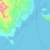
Taba topographic map

Click on the map to display elevation.

About this map

Name: Taba topographic map, elevation, terrain.

Location: Taba, South Sinai, Egypt (29.45282 34.85237 29.53282 34.93237)

Average elevation: 91 m

Minimum elevation: 0 m

Maximum elevation: 449 m

Other topographic maps

Click on a map to view its topography, its elevation and its terrain.
Ras Sudr

Egypt > South Sinai

Average elevation: 17 m

Ras Muhammad National Park

Egypt > South Sinai

Average elevation: 112 m

Abu Galum Protectorate

Egypt > South Sinai

Average elevation: 632 m

Ras Sudr

Egypt > South Sinai

Average elevation: 17 m

Al Tour City

Egypt > South Sinai

Average elevation: 50 m

Wadi Khuraytah

Egypt > South Sinai > Saint Catherine

Average elevation: 1,323 m

Gear up for your next adventure:

🧥Packable Down Jackets - Lightweight warmth that compresses small in your bag
📸Action Camera Chest Mounts - Record your ascent following topographic paths hands-free
🍲Portable Camping Stoves - Fast-boiling stoves for hot meals on remote topographic survey trips
👟Women's Trail Running Shoes - Agile footwear for fell running and technical trails
⌚Altimeter Watches - Watches measuring altitude for mountain activities

As an Amazon Associate, this site earns from qualifying purchases at no extra cost to you.