
Yellapur topographic map
Interactive map
Click on the map to display elevation.
Yellapur
Yellapur is located in the Western Ghats region of Karnataka. It has an average elevation of 541 metres (1774 feet). Among many other hills and valleys, there are two well-known natural falls near Yellapur: Satoddi Falls, 25 km away from the town, and Magod Falls, 19 km away from Yellapur, in the village of Magodu. 17 km from Yellapur is Jenukallu Gudda (Honey-Stone Hill), a viewpoint with a panoramic view of the Western Ghats.
About this map
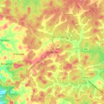
Name: Yellapur topographic map, elevation, terrain.
Average elevation: 529 m
Minimum elevation: 437 m
Maximum elevation: 576 m