
Lakecreek topographic map
Interactive map
Click on the map to display elevation.
About this map
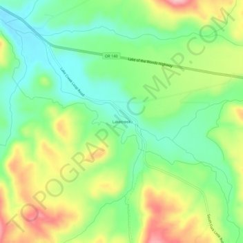
Name: Lakecreek topographic map, elevation, terrain.
Location: Lakecreek, Jackson County, Oregon, United States (42.40235 -122.64614 42.44235 -122.60614)
Average elevation: 538 m
Minimum elevation: 474 m
Maximum elevation: 636 m
Other topographic maps
Click on a map to view its topography, its elevation and its terrain.
Medford
United States > Oregon > Jackson County
Medford, Jackson County, Oregon, United States
Average elevation: 441 m
Buncom
United States > Oregon > Jackson County
Buncom, Jackson County, Oregon, United States
Average elevation: 654 m
Lower Table Rock Trail
United States > Oregon > Jackson County
Lower Table Rock Trail, Jackson County, Oregon, United States
Average elevation: 453 m
Gold Hill
United States > Oregon > Jackson County
Gold Hill, Jackson County, Oregon, United States
Average elevation: 416 m
Rogue River
United States > Oregon > Jackson County
Rogue River, Jackson County, Oregon, 97537, United States
Average elevation: 362 m
Siskiyou Gap
United States > Oregon > Jackson County
Siskiyou Gap, Jackson County, Oregon, United States
Average elevation: 1,746 m
Jacksonville
United States > Oregon > Jackson County
Jacksonville, Jackson County, Oregon, 97530, United States
Average elevation: 522 m