
Thank you for supporting this site ❤️
Make a donation
Make a donation
Gear up for your next adventure:
As an Amazon Associate, this site earns from qualifying purchases at no extra cost to you.
Pahuatla topographic map
Click on the map to display elevation.
Thank you for supporting this site ❤️
Make a donation
Make a donation
Gear up for your next adventure:
As an Amazon Associate, this site earns from qualifying purchases at no extra cost to you.
About this map
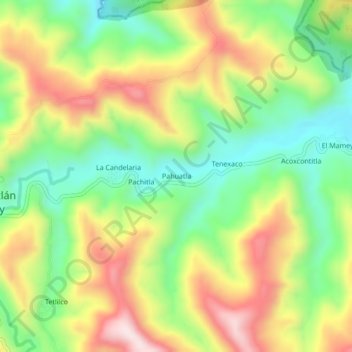
Name: Pahuatla topographic map, elevation, terrain.
Location: Pahuatla, Zontecomatlán de López y Fuentes, Veracruz, México (20.74595 -98.33904 20.78595 -98.29904)
Average elevation: 637 m
Minimum elevation: 428 m
Maximum elevation: 902 m
Thank you for supporting this site ❤️
Make a donation
Make a donation
Gear up for your next adventure:
As an Amazon Associate, this site earns from qualifying purchases at no extra cost to you.