
Pune topographic map
Click on the map to display elevation.
About this map
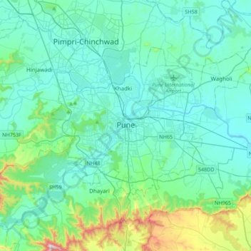
Name: Pune topographic map, elevation, terrain.
Location: Pune, Pune City, Pune District, Maharashtra, 411001, India (18.36137 73.69451 18.68137 74.01451)
Average elevation: 641 m
Minimum elevation: 526 m
Maximum elevation: 1,304 m
Other topographic maps
Click on a map to view its topography, its elevation and its terrain.
Magarpatta City School Ground
India > Maharashtra > Pune City Subdistrict > Pune
Average elevation: 568 m