
Make a donation
Gear up for your next adventure:
As an Amazon Associate, this site earns from qualifying purchases at no extra cost to you.
Toms Brook topographic map
Click on the map to display elevation.
Make a donation
Gear up for your next adventure:
As an Amazon Associate, this site earns from qualifying purchases at no extra cost to you.
About this map
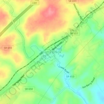
Name: Toms Brook topographic map, elevation, terrain.
Location: Toms Brook, Shenandoah County, Virginia, United States (38.94241 -78.44553 38.95062 -78.43367)
Average elevation: 232 m
Minimum elevation: 193 m
Maximum elevation: 276 m
Make a donation
Gear up for your next adventure:
As an Amazon Associate, this site earns from qualifying purchases at no extra cost to you.
Other topographic maps
Click on a map to view its topography, its elevation and its terrain.
Make a donation
Gear up for your next adventure:
As an Amazon Associate, this site earns from qualifying purchases at no extra cost to you.
Make a donation
Gear up for your next adventure:
As an Amazon Associate, this site earns from qualifying purchases at no extra cost to you.
Shenandoah Caverns
United States > Virginia > Shenandoah County > Mount Jackson
Average elevation: 292 m