
Móng Cái topographic map
Interactive map
Click on the map to display elevation.
About this map
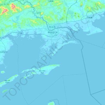
Name: Móng Cái topographic map, elevation, terrain.
Location: Móng Cái, Quảng Ninh Province, 02033, Vietnam (21.23319 107.73263 21.65883 108.11566)
Average elevation: 19 m
Minimum elevation: -5 m
Maximum elevation: 664 m
Other topographic maps
Click on a map to view its topography, its elevation and its terrain.
Hạ Long Bay
Vietnam > Quang Ninh Province > Ha Long
Due to a simultaneous combination of ideal factors such as thick, pale, grey, and strong limestone layers, which are formed by fine-grained materials; hot and moist climate and slow tectonic process as a whole; Hạ Long Bay has had a complete karst evolution for 20 million years. There are many types of karst…
Average elevation: 0 m