
Dornburg topographic map
Interactive map
Click on the map to display elevation.
About this map
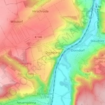
Name: Dornburg topographic map, elevation, terrain.
Average elevation: 232 m
Minimum elevation: 123 m
Maximum elevation: 327 m
Other topographic maps
Click on a map to view its topography, its elevation and its terrain.
Wilsdorf
Deutschland > Thüringen > Saale-Holzland-Kreis > Dornburg-Camburg
Wilsdorf, Dornburg-Camburg, Verwaltungsgemeinschaft Dornburg-Camburg, Saale-Holzland-Kreis, Thüringen, 07778, Deutschland
Average elevation: 275 m