
Make a donation
Gear up for your next adventure:
As an Amazon Associate, this site earns from qualifying purchases at no extra cost to you.
Zacatepec topographic map
Click on the map to display elevation.
Make a donation
Gear up for your next adventure:
As an Amazon Associate, this site earns from qualifying purchases at no extra cost to you.
Zacatepec
San Antonio Chiverías has a population of 1,031 and is located 945 at an altitude of 945 meters. There is one preschool, one elementary school, and one middle school. Its principal economic activities are farming (rice, sorghum, and corn) and ranching (cattle, goats, pigs, and chickens).
Make a donation
Gear up for your next adventure:
As an Amazon Associate, this site earns from qualifying purchases at no extra cost to you.
About this map
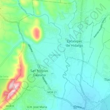
Name: Zacatepec topographic map, elevation, terrain.
Location: Zacatepec, Morelos, Mexico (18.61536 -99.24133 18.68560 -99.17700)
Average elevation: 948 m
Minimum elevation: 889 m
Maximum elevation: 1,180 m
Make a donation
Gear up for your next adventure:
As an Amazon Associate, this site earns from qualifying purchases at no extra cost to you.
Other topographic maps
Click on a map to view its topography, its elevation and its terrain.
Cuernavaca
Mexico > Morelos > Cuernavaca
The city is located in a tropical region, but its temperature is fairly constant at 21–26 °C (70–79 °F). It is located on the southern slope of the Sierra de Chichinautzin mountains. In the morning, warm air flows up the mountains from the valley below and in the late afternoon, cooler air flows down…
Average elevation: 1,822 m
Make a donation
Gear up for your next adventure:
As an Amazon Associate, this site earns from qualifying purchases at no extra cost to you.
Make a donation
Gear up for your next adventure:
As an Amazon Associate, this site earns from qualifying purchases at no extra cost to you.
Cuernavaca
Mexico > Morelos > Cuernavaca
The city is located in a tropical region, but its temperature is fairly constant at 21–26 °C (70–79 °F). It is located on the southern slope of the Sierra de Chichinautzin mountains. In the morning, warm air flows up the mountains from the valley below and in the late afternoon, cooler air flows down…
Average elevation: 1,822 m
Make a donation
Gear up for your next adventure:
As an Amazon Associate, this site earns from qualifying purchases at no extra cost to you.