
Make a donation
Gear up for your next adventure:
As an Amazon Associate, this site earns from qualifying purchases at no extra cost to you.
Irapuato topographic map
Click on the map to display elevation.
Make a donation
Gear up for your next adventure:
As an Amazon Associate, this site earns from qualifying purchases at no extra cost to you.
Irapuato
It has a hot semi-arid climate (Köppen climate classification: BSh) bordering on a humid subtropical climate (Köppen climate classification: Cwa) with an average temperature of 20 °C (68 °F). The large majority of rainfall occurs from June - September. It is at an altitude above sea level of 1,724 meters (5,656 ft).
Make a donation
Gear up for your next adventure:
As an Amazon Associate, this site earns from qualifying purchases at no extra cost to you.
About this map
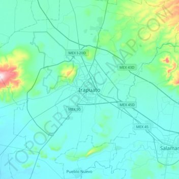
Name: Irapuato topographic map, elevation, terrain.
Location: Irapuato, Guanajuato, 36500, Mexico (20.51588 -101.51211 20.83588 -101.19211)
Average elevation: 1,763 m
Minimum elevation: 1,691 m
Maximum elevation: 2,345 m
Make a donation
Gear up for your next adventure:
As an Amazon Associate, this site earns from qualifying purchases at no extra cost to you.