
Springbok topographic map
Click on the map to display elevation.
Springbok
The town lies at an elevation of 1,007 metres (3,304 feet) in a narrow valley between the high granite domes of the Klein Koperberge (Small Copper Mountains). This name gives away the reason for the early settlement which gradually turned into a major commercial and administrative centre for copper mining operations in the region. While the town initially developed rapidly, this slowed when rich copper deposits were discovered in Okiep. As the main source of water, Springbok continued to develop as the commercial and administrative centre for different mines in the area. Even though mining activities have dwindled, the town remains an important administrative capital in the region and due to its location a favourite stopover for tourists on their way to Namibia. Today the main income is generated from tourism, mining activities, commerce and farming.
About this map
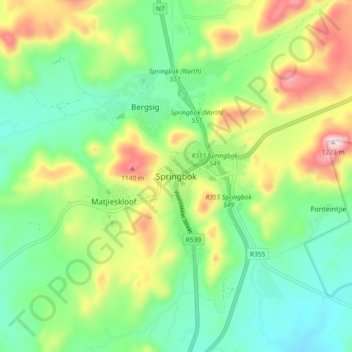
Name: Springbok topographic map, elevation, terrain.
Average elevation: 927 m
Minimum elevation: 768 m
Maximum elevation: 1,228 m
Other topographic maps
Click on a map to view its topography, its elevation and its terrain.
Buffels
South Africa > Northern Cape > Namakwa District Municipality > Nama Khoi Local Municipality > Kleinsee
Average elevation: 18 m