Geolocate

Lingga topographic map

Click on the map to display elevation.

Lingga

Lingga is situated on the southern bank of Lupar River, with Seterap River running through the town. It has an average elevation of 3 metres above the sea level.

Wikipedia (CC-BY-SA 3.0)

About this map

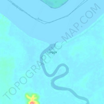
Name: Lingga topographic map, elevation, terrain.

Location: Lingga, Sri Aman, Sri Aman Division, Sarawak, Malaysia (1.31422 111.12942 1.39422 111.20942)

Average elevation: 3 m

Minimum elevation: -4 m

Maximum elevation: 90 m

Gear up for your next adventure:

🥾Hiking Boots - Waterproof and durable boots for long-distance hiking in the UK
🦶Anti-Blister Balms - Protect your feet before long topographic expeditions
🔋Rechargeable Batteries - Eco-friendly power for headlamps and older GPS units
🥤Collapsible Water Bottles - Save space in your rucksack as you consume your water
🧥Softshell Jackets - Breathable jackets for active outdoor use

As an Amazon Associate, this site earns from qualifying purchases at no extra cost to you.