
Murton topographic map
Click on the map to display elevation.
About this map
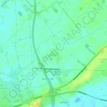
Name: Murton topographic map, elevation, terrain.
Location: Murton, York, England, United Kingdom (53.95373 -1.03185 53.98014 -0.99345)
Average elevation: 17 m
Minimum elevation: 9 m
Maximum elevation: 32 m
York trails, hiking, mountain biking, running and outdoor activities
Other topographic maps
Click on a map to view its topography, its elevation and its terrain.
Askham Bog Nature Reserve
United Kingdom > England > York > Askham Bryan
However, subsequent colonization by common reed, whose fossilized root fragments have been found immediately above the nekron mud layer, lead to a reduced extent of open water. In turn, a layer of fen peat gradually accumulated above the mud in the bog centre to begin forming a raised bog. The increased…
Average elevation: 16 m