
Trancas topographic map
Interactive map
Click on the map to display elevation.
About this map
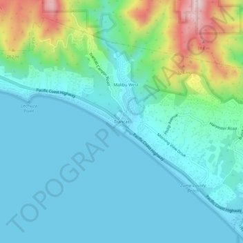
Name: Trancas topographic map, elevation, terrain.
Average elevation: 85 m
Minimum elevation: -2 m
Maximum elevation: 422 m
Other topographic maps
Click on a map to view its topography, its elevation and its terrain.
Las Flores
United States > California > Los Angeles County > Malibu
Las Flores, Malibu, Los Angeles County, California, United States
Average elevation: 101 m