
Łeba topographic map
Interactive map
Click on the map to display elevation.
About this map
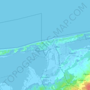
Name: Łeba topographic map, elevation, terrain.
Location: Łeba, Lębork County, Pomeranian Voivodeship, Poland (54.73734 17.49125 54.78334 17.67246)
Average elevation: 1 m
Minimum elevation: -5 m
Maximum elevation: 41 m
Other topographic maps
Click on a map to view its topography, its elevation and its terrain.
Rąbka
Poland > Pomeranian Voivodeship > Lębork County > Łeba > Rąbka
Rąbka, Łeba, Lębork County, Pomeranian Voivodeship, 84-360, Poland
Average elevation: -1 m