
Hauchenberg topographic map
Interactive map
Click on the map to display elevation.
About this map
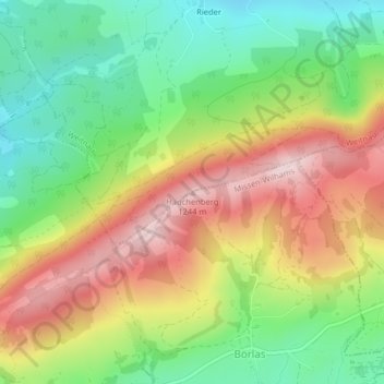
Name: Hauchenberg topographic map, elevation, terrain.
Average elevation: 1,031 m
Minimum elevation: 864 m
Maximum elevation: 1,236 m
Other topographic maps
Click on a map to view its topography, its elevation and its terrain.
Berg
Deutschland > Bayern > Landkreis Oberallgäu > Missen-Wilhams > Berg
Berg, Missen-Wilhams, Weitnau (VGem), Landkreis Oberallgäu, Bayern, 87547, Deutschland
Average elevation: 972 m