
Fosses-la-Ville topographic map
Interactive map
Click on the map to display elevation.
About this map
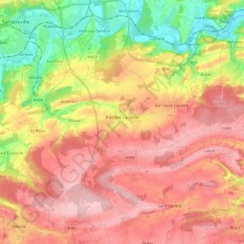
Name: Fosses-la-Ville topographic map, elevation, terrain.
Location: Fosses-la-Ville, Namur, Wallonia, 5070, Belgium (50.35828 4.58443 50.42817 4.79898)
Average elevation: 192 m
Minimum elevation: 80 m
Maximum elevation: 281 m
Other topographic maps
Click on a map to view its topography, its elevation and its terrain.
Balâtre
Belgium > Namur > Namur > Jemeppe-sur-Sambre
Balâtre, Jemeppe-sur-Sambre, Namur, Wallonia, Belgium
Average elevation: 145 m