Geolocate

Union Bridge topographic map

Interactive map

Click on the map to display elevation.

About this map

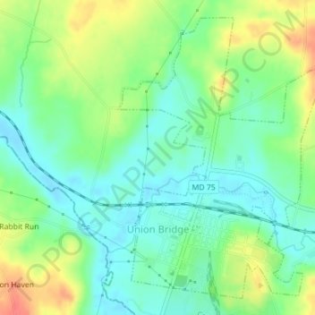
Name: Union Bridge topographic map, elevation, terrain.

Location: Union Bridge, Carroll County, Maryland, United States (39.56252 -77.18594 39.58659 -77.16102)

Average elevation: 138 m

Minimum elevation: 116 m

Maximum elevation: 176 m

Other topographic maps

Click on a map to view its topography, its elevation and its terrain.

Gist

United States > Maryland > Carroll County

Gist, Carroll County, Maryland, United States

Average elevation: 203 m

Mount Airy

United States > Maryland > Carroll County

Mount Airy, Carroll County, Maryland, 21771, United States

Average elevation: 221 m

Kimberly Heights

United States > Maryland > Carroll County

Kimberly Heights, Carroll County, Maryland, United States

Average elevation: 209 m

Westminster

United States > Maryland > Carroll County

Westminster, Carroll County, Maryland, United States

Average elevation: 228 m

Sykesville

United States > Maryland > Carroll County > Sykesville

Sykesville, Carroll County, Maryland, United States

Average elevation: 152 m