
Saint-Lin–Laurentides topographic map
Interactive map
Click on the map to display elevation.
About this map
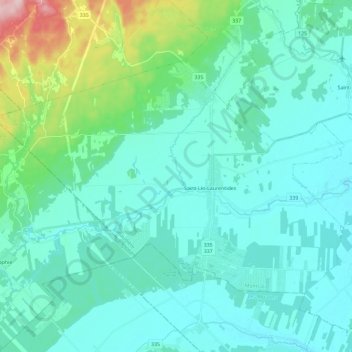
Name: Saint-Lin–Laurentides topographic map, elevation, terrain.
Location: Saint-Lin–Laurentides, Montcalm, Lanaudière, Québec, Canada (45.80438 -73.90094 45.91117 -73.67065)
Average elevation: 87 m
Minimum elevation: 49 m
Maximum elevation: 290 m
Other topographic maps
Click on a map to view its topography, its elevation and its terrain.
Saint-Roch-de-l'Achigan
Canada > Québec > Montcalm > Saint-Roch-de-l'Achigan
Saint-Roch-de-l'Achigan, Montcalm, Lanaudière, Québec, J0K 3H0, Canada
Average elevation: 46 m