
Schoonover Buttes topographic map
Interactive map
Click on the map to display elevation.
About this map
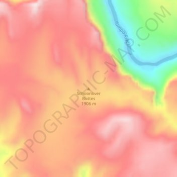
Name: Schoonover Buttes topographic map, elevation, terrain.
Location: Schoonover Buttes, Moffat County, Colorado, United States (40.47992 -108.77711 40.48002 -108.77701)
Average elevation: 1,902 m
Minimum elevation: 1,621 m
Maximum elevation: 2,049 m
Other topographic maps
Click on a map to view its topography, its elevation and its terrain.
Craig
United States > Colorado > Moffat County > Craig
Craig, Moffat County, Colorado, 81625, United States
Average elevation: 1,923 m