
Irchester topographic map
Click on the map to display elevation.
Irchester
The 12th-century English historian Henry of Huntingdon mentions a Roman "town on the river (Nene), in Huntingdonshire, which is entirely destroyed" as one of his interpretations of the 28 cities of Britain. The town is mentioned also by William Lambarde in Dictionarium Angliae Topographicum & Historicum.
About this map
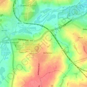
Name: Irchester topographic map, elevation, terrain.
Location: Irchester, North Northamptonshire, England, United Kingdom (52.26827 -0.68572 52.30521 -0.61055)
Average elevation: 62 m
Minimum elevation: 32 m
Maximum elevation: 98 m
North Northamptonshire trails, hiking, mountain biking, running and outdoor activities
Other topographic maps
Click on a map to view its topography, its elevation and its terrain.
Irchester Country Park
United Kingdom > England > North Northamptonshire > Little Irchester
Average elevation: 60 m
River Nene Navigation
United Kingdom > England > North Northamptonshire > Irchester
Average elevation: 55 m