
Accursed Mountains topographic map
Interactive map
Click on the map to display elevation.
About this map
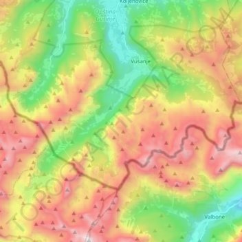
Name: Accursed Mountains topographic map, elevation, terrain.
Location: Accursed Mountains, Gusinje Municipality, Montenegro (42.48018 19.76404 42.51613 19.91845)
Average elevation: 1,676 m
Minimum elevation: 830 m
Maximum elevation: 2,679 m
The Accursed Mountains are a typical Dinaric karst high mountain range with a pronounced steep topography and glacial features. Maximum relief differences of 1,800 metres (5,900 ft) are found in the Valbona, Grbaja and Ropojani and Cem valleys. Overhanging walls and ridges forming pointed peaks are typical of the western and central Accursed Mountains. The eastern mountains are less rugged with lower relief. The valleys show characteristic effects of Pleistocene glaciation. Most of the area was modified by glacial activity with karstic areas in the western parts.
Other topographic maps
Click on a map to view its topography, its elevation and its terrain.
Gusinje
Montenegro > Gusinje Municipality
Gusinje, Gusinje Municipality, 84326, Montenegro
Average elevation: 1,295 m