Geolocate

Sharm topographic map

Click on the map to display elevation.

About this map

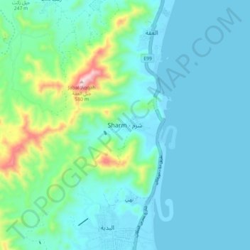
Name: Sharm topographic map, elevation, terrain.

Location: Sharm, Fujairah Emirate, United Arab Emirates (25.43080 56.30893 25.51080 56.38893)

Average elevation: 95 m

Minimum elevation: -6 m

Maximum elevation: 584 m

Other topographic maps

Click on a map to view its topography, its elevation and its terrain.

Marbad

United Arab Emirates > Fujairah Emirate

Average elevation: 459 m

Qidfa

United Arab Emirates > Fujairah Emirate

Average elevation: 42 m

Masafi

United Arab Emirates > Fujairah Emirate

Average elevation: 582 m

Sharm

United Arab Emirates > Fujairah Emirate

Average elevation: 137 m

Gear up for your next adventure:

🧥Softshell Jackets - Breathable jackets for active outdoor use
🦟Anti-Midge & Tick Repellent - Vital for hiking in the Scottish Highlands during summer
👟Waterproof Leg Gaiters - Keep mud and water out of your boots in boggy terrain
🧥Packable Down Jackets - Lightweight warmth that compresses small in your bag
🌄Compact Monoculars - Lightweight optics for hiking

As an Amazon Associate, this site earns from qualifying purchases at no extra cost to you.