
Dorna-Arini topographic map
Interactive map
Click on the map to display elevation.
About this map
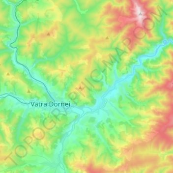
Name: Dorna-Arini topographic map, elevation, terrain.
Location: Dorna-Arini, Suceava, Romania (47.28017 25.38180 47.44740 25.54101)
Average elevation: 1,078 m
Minimum elevation: 744 m
Maximum elevation: 1,847 m
Other topographic maps
Click on a map to view its topography, its elevation and its terrain.
Câmpulung Moldovenesc
Romania > Suceava > Câmpulung Moldovenesc > Câmpulung Moldovenesc
Average elevation: 834 m