
Hillhall topographic map
Interactive map
Click on the map to display elevation.
About this map
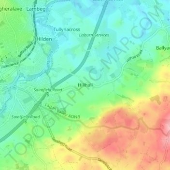
Name: Hillhall topographic map, elevation, terrain.
Average elevation: 61 m
Minimum elevation: 17 m
Maximum elevation: 158 m
Other topographic maps
Click on a map to view its topography, its elevation and its terrain.
Benraw
United Kingdom > Northern Ireland > County Down
Benraw, County Down, Ulster, Northern Ireland, United Kingdom
Average elevation: 182 m
Newry
United Kingdom > Northern Ireland > County Down
Newry, County Down, Northern Ireland, United Kingdom
Average elevation: 73 m
Banbridge
United Kingdom > Northern Ireland > County Down
Banbridge, County Down, Northern Ireland, BT32 3DB, United Kingdom
Average elevation: 90 m
Carryduff
United Kingdom > Northern Ireland > County Down > Carryduff
Carryduff, County Down, Northern Ireland, BT8 8DN, United Kingdom
Average elevation: 110 m
Newry
United Kingdom > Northern Ireland > County Down > Newry
Newry, County Down, Northern Ireland, BT34 1DG, United Kingdom
Average elevation: 129 m
Slieve Donard
United Kingdom > Northern Ireland > County Down
Slieve Donard, County Down, Northern Ireland, BT33 0HD, United Kingdom
Average elevation: 505 m