
Turn Island topographic map
Interactive map
Click on the map to display elevation.
About this map
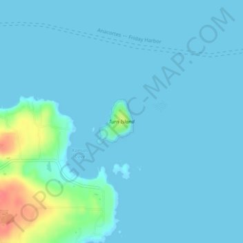
Name: Turn Island topographic map, elevation, terrain.
Location: Turn Island, San Juan County, Washington, USA (48.53071 -122.97518 48.53578 -122.96903)
Average elevation: 7 m
Minimum elevation: -1 m
Maximum elevation: 61 m
Other topographic maps
Click on a map to view its topography, its elevation and its terrain.
Strait of Juan de Fuca
Strait of Juan de Fuca, Clallam County, Washington, USA
Average elevation: 0 m
Sumas Mountain
Sumas Mountain, Whatcom County, Washington, USA
Average elevation: 782 m
Chehalis River
Chehalis River, Lewis County, Washington, 98544, USA
Average elevation: 95 m
Chilliwack River
Chilliwack River, Whatcom County, Washington, USA
Average elevation: 1,389 m
Skagit River
Skagit River, Whatcom County, Washington, 98267, USA
Average elevation: 1,391 m
Lake Washington
USA > Washington > Medina
Lake Washington, 73rd Avenue Northeast, Medina, King County, Washington, 98039, USA
Average elevation: 58 m
Albion
USA > Washington > Albion
Albion, Whitman County, Washington, 99102, USA
Average elevation: 725 m
Klickitat Glacier
Klickitat Glacier, South Climb Trail #183, Yakima County, Washington, USA
Average elevation: 2,434 m
Ice Cliff Glacier
Ice Cliff Glacier, Horseshoe Lake Trail, Chelan County, Washington, USA
Average elevation: 2,090 m
Boston Glacier
Boston Glacier, Sahale Arm Trail, Skagit County, Washington, USA
Average elevation: 1,969 m
Snow Creek Glacier
Snow Creek Glacier, Little Annapurna summit trail, Chelan County, Washington, USA
Average elevation: 2,225 m
Davenport Glacier
Davenport Glacier, Sahale Arm Trail, Skagit County, Washington, USA
Average elevation: 2,143 m
Borealis Glacier
Borealis Glacier, Lucky ridge boot trail, Skagit County, Washington, USA
Average elevation: 1,851 m
Mount Seattle
Mount Seattle, Jefferson County, Washington, USA
Average elevation: 1,441 m
Meade Glacier
Meade Glacier, Pacific Crest Trail, Yakima County, Washington, USA
Average elevation: 2,010 m
Williwakas Glacier
USA > Washington > Paradise
Williwakas Glacier, Paradise Glacier Trail, Paradise, Pierce County, Washington, USA
Average elevation: 1,998 m
Upper Curtis Glacier
Upper Curtis Glacier, Sulfide Glacier Route, Whatcom County, Washington, USA
Average elevation: 2,059 m
Crystal Glacier
Crystal Glacier, Sulfide Glacier Route, Whatcom County, Washington, USA
Average elevation: 2,145 m
Kimtah Glacier
Kimtah Glacier, Fisher Creek Trail, Skagit County, Washington, USA
Average elevation: 1,996 m
Fremont Glacier
Fremont Glacier, Thunder Creek Trail, Skagit County, Washington, USA
Average elevation: 2,216 m
Entiat Glacier
Entiat Glacier, Mount Maude Summit Approach, Chelan County, Washington, USA
Average elevation: 2,145 m
Yawning Glacier
Yawning Glacier, Ptarmigan Traverse, Chelan County, Washington, USA
Average elevation: 1,712 m
Hubert Glacier
Hubert Glacier, Blue Glacier Primitive Trail, Jefferson County, Washington, USA
Average elevation: 1,802 m
South Cascade Glacier
South Cascade Glacier, Ptarmigan Traverse, Chelan County, Washington, USA
Average elevation: 1,972 m
Cool Glacier
Cool Glacier, Snohomish County, Washington, USA
Average elevation: 2,503 m
Colonial Glacier
USA > Washington > Diablo
Colonial Glacier, Pyramid Lake Trail, Diablo, Whatcom County, Washington, USA
Average elevation: 1,847 m
No Name Glacier
No Name Glacier, Hadley Peak Route, Whatcom County, Washington, USA
Average elevation: 1,984 m
Mazama Glacier
Mazama Glacier, South Climb Trail #183, Yakima County, Washington, USA
Average elevation: 2,568 m
Talum Glaciers
Talum Glaciers, Squak Glacier Route, Whatcom County, Washington, USA
Average elevation: 2,118 m
Carbon Glacier
Carbon Glacier, Wonderland Trail, Pierce County, Washington, USA
Average elevation: 2,047 m
Spire Glacier
Spire Glacier, Ptarmigan Traverse, Chelan County, Washington, USA
Average elevation: 1,946 m
Jerry Glacier
USA > Washington > Anacortes Crossing
Jerry Glacier, Jackita Ridge Trail, Anacortes Crossing, Whatcom County, Washington, USA
Average elevation: 1,893 m
Quien Sabe Glacier
Quien Sabe Glacier, Sahale Arm Trail, Skagit County, Washington, USA
Average elevation: 2,143 m
Whitman Glacier
Whitman Glacier, Wonderland Trail, Pierce County, Washington, USA
Average elevation: 2,519 m
Sulphide Glacier
Sulphide Glacier, Sulfide Glacier Route, Whatcom County, Washington, USA
Average elevation: 1,815 m
First Hill
USA > Washington > Mercer Island
First Hill, Mercer Island, King County, Washington, 98040, USA
Average elevation: 31 m
Goode Glacier
Goode Glacier, North Fork Bridge Creek, Chelan County, Washington, USA
Average elevation: 1,877 m
Ice River Glacier
Ice River Glacier, Blue Glacier Primitive Trail, Jefferson County, Washington, USA
Average elevation: 1,640 m
Hadley Glacier
Hadley Glacier, Hadley Peak Route, Whatcom County, Washington, USA
Average elevation: 1,815 m
Sahale Glacier
Sahale Glacier, Sahale Arm Trail, Skagit County, Washington, USA
Average elevation: 2,062 m
Liberty Cap Glacier
Liberty Cap Glacier, Emmons Glacier Route, Pierce County, Washington, USA
Average elevation: 3,465 m
Lynch Glacier
Lynch Glacier, Jade Lake Trail, King County, Washington, USA
Average elevation: 1,962 m
Puget Sound
USA > Washington > Edmonds
Puget Sound, Admiral Way, Edmonds, Snohomish County, Washington, 98020, USA
Average elevation: 0 m
Sandalee Glacier
Sandalee Glacier, McGregor Trail, Chelan County, Washington, USA
Average elevation: 1,910 m
Isella Glacier
USA > Washington > Holden Village
Isella Glacier, Cloudy Pass Trail #1256, Holden Village, Chelan County, Washington, USA
Average elevation: 2,258 m
Challenger Glacier
Challenger Glacier, Little Beaver Trail, Whatcom County, Washington, USA
Average elevation: 1,924 m