
Arenal topographic map
Interactive map
Click on the map to display elevation.
About this map
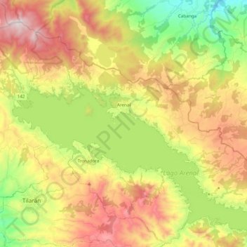
Name: Arenal topographic map, elevation, terrain.
Average elevation: 652 m
Minimum elevation: 170 m
Maximum elevation: 1,207 m
Other topographic maps
Click on a map to view its topography, its elevation and its terrain.
Arenal
Costa Rica > Cantón Tilarán > Arenal > Arenal
Arenal, Cantón Tilarán, Provincia Guanacaste, 50807, Costa Rica
Average elevation: 601 m