
محافظة الجيزة topographic map
Interactive map
Click on the map to display elevation.
About this map
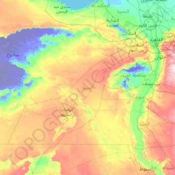
Name: محافظة الجيزة topographic map, elevation, terrain.
Location: محافظة الجيزة, Egypte (27.73800 27.31059 30.34009 31.90628)
Average elevation: 134 m
Minimum elevation: -103 m
Maximum elevation: 661 m
Other topographic maps
Click on a map to view its topography, its elevation and its terrain.
وراق الحضر
Egypte > محافظة الجيزة > وراق الحضر
وراق الحضر, محافظة الجيزة, 22222, Egypte
Average elevation: 21 m