
Make a donation
Gear up for your next adventure:
As an Amazon Associate, this site earns from qualifying purchases at no extra cost to you.
Roggan River topographic map
Click on the map to display elevation.
Make a donation
Gear up for your next adventure:
As an Amazon Associate, this site earns from qualifying purchases at no extra cost to you.
About this map
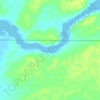
Name: Roggan River topographic map, elevation, terrain.
Location: Roggan River, Eeyou Istchee, Northern Quebec, Quebec, Canada (54.39612 -79.44455 54.41612 -79.42455)
Average elevation: 8 m
Minimum elevation: -5 m
Maximum elevation: 16 m
Make a donation
Gear up for your next adventure:
As an Amazon Associate, this site earns from qualifying purchases at no extra cost to you.
Other topographic maps
Click on a map to view its topography, its elevation and its terrain.
Whapmagoostui (Category I Land)
Canada > Quebec > Eeyou Istchee > Whapmagoostui (Village)
Average elevation: 91 m
Make a donation
Gear up for your next adventure:
As an Amazon Associate, this site earns from qualifying purchases at no extra cost to you.