
Make a donation
Gear up for your next adventure:
As an Amazon Associate, this site earns from qualifying purchases at no extra cost to you.
Christian Island topographic map
Click on the map to display elevation.
Make a donation
Gear up for your next adventure:
As an Amazon Associate, this site earns from qualifying purchases at no extra cost to you.
Christian Island
Christian Island is a large island in Georgian Bay close to the communities of Penetanguishene and Midland, Ontario. The island, with its neighbours Hope Island and Beckwith Island, is a 5,428.1 hectares (13,413.1 acres) Ojibwa reserve, known as Christian Island Indian Reserve No. 30. Together with the 7.5 hectares (18.5 acres) Christian Island Indian Reserve No. 30A located at Cedar Point, Ontario and the 3.1 hectares (7.7 acres) Chippewa Island Indian Reserve located in Twelve Mile Sound, 27.5 kilometres (17.1 mi) north of Christian Island, it forms the land base for the Beausoleil First Nation. Christian Islands' highest elevation is 209 metres (686 feet) above sea level.
Make a donation
Gear up for your next adventure:
As an Amazon Associate, this site earns from qualifying purchases at no extra cost to you.
About this map
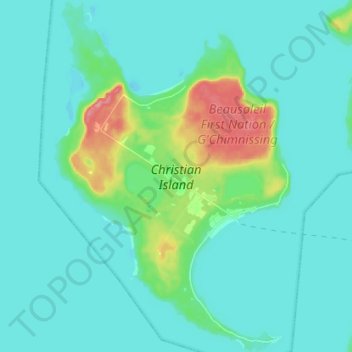
Name: Christian Island topographic map, elevation, terrain.
Average elevation: 185 m
Minimum elevation: 171 m
Maximum elevation: 259 m
Make a donation
Gear up for your next adventure:
As an Amazon Associate, this site earns from qualifying purchases at no extra cost to you.
Other topographic maps
Click on a map to view its topography, its elevation and its terrain.
Wasaga Beach
Canada > Ontario > Simcoe County
The Town of Wasaga Beach covers an area of 61.13 square kilometres (23.60 sq mi) composed predominantly of sand and loamy sand that exhibit excessive to good drainage and irregular to moderately sloping topography. The poor soil quality makes it difficult to sustain lush lawns in the town. The Canada Land…
Average elevation: 190 m
Make a donation
Gear up for your next adventure:
As an Amazon Associate, this site earns from qualifying purchases at no extra cost to you.
Wasaga Beach Provincial Park
Canada > Ontario > Simcoe County > Wasaga Beach
The Town of Wasaga Beach covers an area of 61.13 square kilometres (23.60 sq mi) comprised predominantly of sand and loamy sand that exhibit excessive to good drainage and irregular to moderately sloping topography. The poor soil quality makes it difficult to sustain lush lawns in the town. The Canada Land…
Average elevation: 185 m
Make a donation
Gear up for your next adventure:
As an Amazon Associate, this site earns from qualifying purchases at no extra cost to you.
Make a donation
Gear up for your next adventure:
As an Amazon Associate, this site earns from qualifying purchases at no extra cost to you.