
Make a donation
Gear up for your next adventure:
As an Amazon Associate, this site earns from qualifying purchases at no extra cost to you.
Coimbra topographic map
Click on the map to display elevation.
Make a donation
Gear up for your next adventure:
As an Amazon Associate, this site earns from qualifying purchases at no extra cost to you.
Coimbra
Despite being relatively distant from the coast, Coimbra also has a marked Atlantic influence due to the floodplain of the Mondego River which crosses the city, making both its winters and summers milder than they would otherwise be. This influence also makes cold waves less frequent and less intense, however, days with minimum negative temperatures and cold waves are still present occasionally. Topography is also an important factor to consider in regard to nighttime temperatures, the presence of cold air lakes, in topographically depressed areas at certain synoptic situations, can also lead to pronounced colder temperatures.
Make a donation
Gear up for your next adventure:
As an Amazon Associate, this site earns from qualifying purchases at no extra cost to you.
About this map
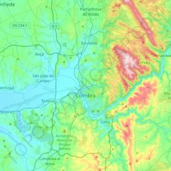
Name: Coimbra topographic map, elevation, terrain.
Location: Coimbra, Portugal (40.09892 -8.59168 40.35201 -8.31290)
Average elevation: 129 m
Minimum elevation: 3 m
Maximum elevation: 536 m
Make a donation
Gear up for your next adventure:
As an Amazon Associate, this site earns from qualifying purchases at no extra cost to you.
Other topographic maps
Click on a map to view its topography, its elevation and its terrain.
Make a donation
Gear up for your next adventure:
As an Amazon Associate, this site earns from qualifying purchases at no extra cost to you.
Make a donation
Gear up for your next adventure:
As an Amazon Associate, this site earns from qualifying purchases at no extra cost to you.
Make a donation
Gear up for your next adventure:
As an Amazon Associate, this site earns from qualifying purchases at no extra cost to you.
Make a donation
Gear up for your next adventure:
As an Amazon Associate, this site earns from qualifying purchases at no extra cost to you.
Make a donation
Gear up for your next adventure:
As an Amazon Associate, this site earns from qualifying purchases at no extra cost to you.
Make a donation
Gear up for your next adventure:
As an Amazon Associate, this site earns from qualifying purchases at no extra cost to you.
Make a donation
Gear up for your next adventure:
As an Amazon Associate, this site earns from qualifying purchases at no extra cost to you.
Lousã
Portugal > Coimbra > Lousã e Vilarinho
Lousã sits at around 200 m (660 ft) high, and it currently has an active station at its aerodrome, but because this station is relatively new, data from the older, now inactive station in the mountains nearby, at a higher altitude, is also represented in the climate chart below.
Average elevation: 335 m
Make a donation
Gear up for your next adventure:
As an Amazon Associate, this site earns from qualifying purchases at no extra cost to you.
Make a donation
Gear up for your next adventure:
As an Amazon Associate, this site earns from qualifying purchases at no extra cost to you.
Ninho do Grou
Portugal > Coimbra > Seixo de Gatões > Seixo de Gatões > Ninho do Grou
Average elevation: 60 m
Make a donation
Gear up for your next adventure:
As an Amazon Associate, this site earns from qualifying purchases at no extra cost to you.