
Ouled Yaïch topographic map
Interactive map
Click on the map to display elevation.
About this map
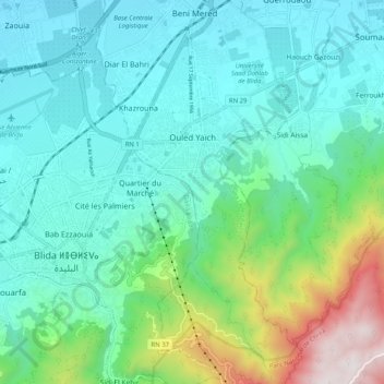
Name: Ouled Yaïch topographic map, elevation, terrain.
Location: Ouled Yaïch, Ouled Yaich District, Blida, Algeria (36.44428 2.84478 36.52626 2.89010)
Average elevation: 402 m
Minimum elevation: 110 m
Maximum elevation: 1,458 m
Other topographic maps
Click on a map to view its topography, its elevation and its terrain.
Chrea
Algeria > Blida > Ouled Yaich District > Chrea
Chrea, Ouled Yaich District, Blida, Algeria
Average elevation: 1,293 m