Geolocate

Almelo topographic map

Click on the map to display elevation.

Almelo

Topographic map of Almelo, Sept. 2014

Wikipedia (CC-BY-SA 3.0)

About this map

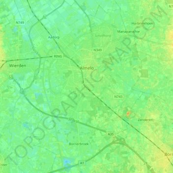
Name: Almelo topographic map, elevation, terrain.

Location: Almelo, Overijssel, Netherlands (52.28997 6.59770 52.39912 6.72117)

Average elevation: 12 m

Minimum elevation: 4 m

Maximum elevation: 25 m

Other topographic maps

Click on a map to view its topography, its elevation and its terrain.

Witteberg

Netherlands > Overijssel

Average elevation: 57 m

Zuurberg

Netherlands > Overijssel > Holten

Average elevation: 17 m

Tankenberg

Netherlands > Overijssel > de Lutte

Average elevation: 58 m

Helhuizen

Netherlands > Overijssel > Holten

Average elevation: 20 m

Usselo

Netherlands > Overijssel > Enschede

Average elevation: 31 m

Frankhuis

Netherlands > Overijssel > Zwolle

Average elevation: 3 m

Enschede

Netherlands > Overijssel > Enschede

Average elevation: 34 m

Gear up for your next adventure:

Lightweight Tents - Compact tents for backpacking and trekking
🦟Anti-Midge & Tick Repellent - Vital for hiking in the Scottish Highlands during summer
📷Camera Straps - Secure straps for carrying cameras while walking
🛑Emergency Bivvy Bags - Heat-reflective survival bags for unexpected nights out
🧊Personal Water Filters - Drink safely from mountain streams marked on your map

As an Amazon Associate, this site earns from qualifying purchases at no extra cost to you.