
Make a donation
Gear up for your next adventure:
As an Amazon Associate, this site earns from qualifying purchases at no extra cost to you.
Fordland topographic map
Click on the map to display elevation.
Make a donation
Gear up for your next adventure:
As an Amazon Associate, this site earns from qualifying purchases at no extra cost to you.
Fordland
Due to favorable geographical conditions (e.g., altitude—Fordland is approximately 300 feet higher in elevation than Springfield), numerous Springfield-based media outlets, such as KYTV, KOLR, KOZL-TV, KGHZ, and others, have located their transmitting towers in or near Fordland.
Make a donation
Gear up for your next adventure:
As an Amazon Associate, this site earns from qualifying purchases at no extra cost to you.
About this map
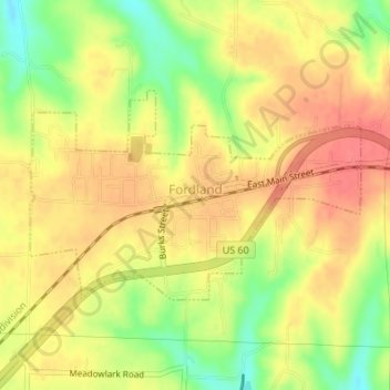
Name: Fordland topographic map, elevation, terrain.
Location: Fordland, Webster County, Missouri, United States (37.14986 -92.95531 37.16439 -92.92634)
Average elevation: 480 m
Minimum elevation: 443 m
Maximum elevation: 503 m
Make a donation
Gear up for your next adventure:
As an Amazon Associate, this site earns from qualifying purchases at no extra cost to you.
Other topographic maps
Click on a map to view its topography, its elevation and its terrain.