
Behbahan topographic map
Interactive map
Click on the map to display elevation.
About this map
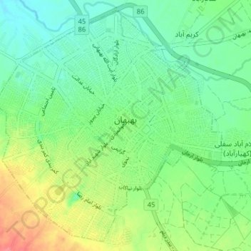
Name: Behbahan topographic map, elevation, terrain.
Location: Behbahan, بخش مرکزی, Behbahan County, Khuzestan Province, Iran (30.56730 50.20974 30.61820 50.26803)
Average elevation: 327 m
Minimum elevation: 304 m
Maximum elevation: 366 m
Other topographic maps
Click on a map to view its topography, its elevation and its terrain.
گرمز سفلی
Iran > Khuzestan Province > Behbahan County > دهستان حومه
گرمز سفلی, دهستان حومه, بخش مرکزی, Behbahan County, Khuzestan Province, Iran
Average elevation: 381 m
Behbahan
Iran > Khuzestan Province > Behbahan County > Behbahan
Behbahan, دهستان بهبهان, بخش مرکزی, Behbahan County, Khuzestan Province, 63618, Iran
Average elevation: 330 m