
Thank you for supporting this site ❤️
Make a donation
Make a donation
Gear up for your next adventure:
As an Amazon Associate, this site earns from qualifying purchases at no extra cost to you.
Mesetas topographic map
Click on the map to display elevation.
Thank you for supporting this site ❤️
Make a donation
Make a donation
Gear up for your next adventure:
As an Amazon Associate, this site earns from qualifying purchases at no extra cost to you.
About this map
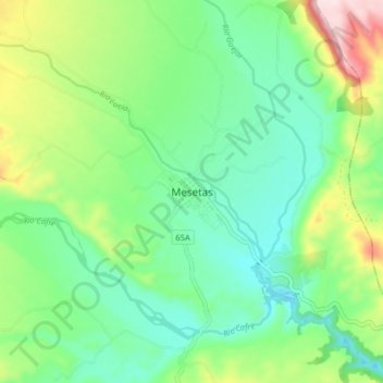
Name: Mesetas topographic map, elevation, terrain.
Location: Mesetas, Ariari, Meta, RAP (Especial) Central, Colombia (3.34403 -74.08387 3.42403 -74.00387)
Average elevation: 582 m
Minimum elevation: 476 m
Maximum elevation: 824 m
Thank you for supporting this site ❤️
Make a donation
Make a donation
Gear up for your next adventure:
As an Amazon Associate, this site earns from qualifying purchases at no extra cost to you.