Geolocate

Wilbraham topographic map

Interactive map

Click on the map to display elevation.

About this map

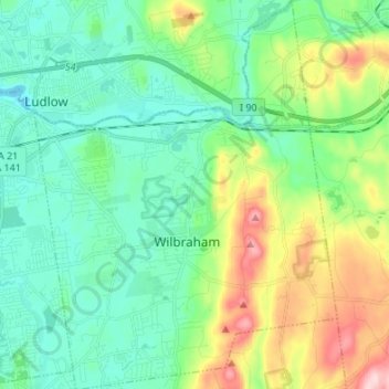
Name: Wilbraham topographic map, elevation, terrain.

Location: Wilbraham, Hampden County, Massachusetts, 01095, United States (42.08477 -72.48456 42.18482 -72.37944)

Average elevation: 119 m

Minimum elevation: 50 m

Maximum elevation: 304 m

Other topographic maps

Click on a map to view its topography, its elevation and its terrain.

Blandford

United States > Massachusetts > Hampden County

The town is located near the eastern edge of the Berkshire Hills, above an ancient rift zone where the Connecticut River Valley is downfaulted approximately 1,000 feet (300 m). The town's elevations range from about 400 feet (120 m) above sea level along streams approaching the Westfield River (a major…

Average elevation: 346 m

Westfield

United States > Massachusetts > Hampden County

Average elevation: 100 m

Springfield

United States > Massachusetts > Hampden County

Aside from its rivers, Springfield's second most prominent topographical feature is the city's 735-acre (297 ha) Forest Park. Forest Park lies in the southwestern corner of the city, surrounded by Springfield's attractive garden districts, Forest Park and Forest Park Heights, which feature over 600 Victorian…

Average elevation: 50 m

Granville

United States > Massachusetts > Hampden County

Average elevation: 242 m

Woronoco

United States > Massachusetts > Hampden County > Russell

Average elevation: 190 m

Tolland

United States > Massachusetts > Hampden County

Average elevation: 395 m

Ludlow

United States > Massachusetts > Hampden County

Average elevation: 95 m

Hampden

United States > Massachusetts > Hampden County > Hampden

According to the United States Census Bureau, the town has a total area of 19.6 square miles (51 km2), of which 19.6 square miles (51 km2) is land and 0.05% is water. Hampden is located at the eastern edge of the Connecticut River Valley. Hills rise up to over 1,000 feet (300 m) above sea level, from the…

Average elevation: 143 m

Wales

United States > Massachusetts > Hampden County

Average elevation: 302 m

Chicopee

United States > Massachusetts > Hampden County

Willimansett, and portions of the Center and Falls are on low land, with Aldenville, Fairview, Westover, and the Burnett Road neighborhoods on an elevated plateau. At 288 feet, the highest elevation in the city is on Old Lyman Road, in the Fairview section.

Average elevation: 67 m

Skyland

United States > Massachusetts > Hampden County > Tolland > Skyland

Average elevation: 369 m

Agawam

United States > Massachusetts > Hampden County

Average elevation: 48 m

Palmer

United States > Massachusetts > Hampden County

Average elevation: 154 m