
Make a donation
Gear up for your next adventure:
As an Amazon Associate, this site earns from qualifying purchases at no extra cost to you.
Uliastai topographic map
Click on the map to display elevation.
Make a donation
Gear up for your next adventure:
As an Amazon Associate, this site earns from qualifying purchases at no extra cost to you.
About this map
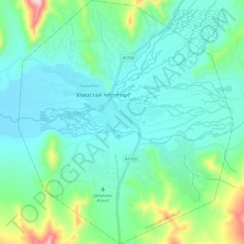
Name: Uliastai topographic map, elevation, terrain.
Location: Uliastai, Zavkhan, Mongolia (47.69912 96.81151 47.76831 96.90236)
Average elevation: 1,833 m
Minimum elevation: 1,738 m
Maximum elevation: 2,209 m
Make a donation
Gear up for your next adventure:
As an Amazon Associate, this site earns from qualifying purchases at no extra cost to you.
Other topographic maps
Click on a map to view its topography, its elevation and its terrain.
Отгонтэнгэр
Mongolia > Zavkhan > Aldarkhaan
Otgontenger (/ˌɒtɡɒnˈtɛŋɡər/; Mongolian: Отгонтэнгэр [ˈɔʰtχɞɴtʰɪŋɡɪ̆r]; lit. 'The Youngest Sky') is the highest peak in the Khangai Mountains in Mongolia. Its summit is currently calculated to reach an elevation of 4,010 meters above mean sea level (some earlier topographic…
Average elevation: 3,397 m