Geolocate

Center Ridge topographic map

Click on the map to display elevation.

About this map

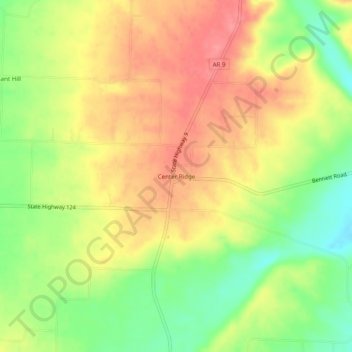
Name: Center Ridge topographic map, elevation, terrain.

Location: Center Ridge, Conway County, Arkansas, 72027, United States (35.35397 -92.58294 35.39397 -92.54294)

Average elevation: 211 m

Minimum elevation: 168 m

Maximum elevation: 245 m

Other topographic maps

Click on a map to view its topography, its elevation and its terrain.

Brewer Lake

United States > Arkansas > Conway County

Average elevation: 115 m

Morrilton

United States > Arkansas > Conway County

Average elevation: 103 m

Plumerville

United States > Arkansas > Conway County

Average elevation: 106 m

Morrilton

United States > Arkansas > Conway County

Average elevation: 103 m

Gear up for your next adventure:

🥼Base Layers - Thermal base layers for temperature regulation
🦟Anti-Midge & Tick Repellent - Vital for hiking in the Scottish Highlands during summer
🗺️Ordnance Survey Maps - Essential paper maps for hiking across the UK national parks
🔋Power Banks - Portable chargers for long outdoor trips
🧣Fleece Neck Warmers - Extra insulation for winter topographic surveys

As an Amazon Associate, this site earns from qualifying purchases at no extra cost to you.