
Ermelo topographic map
Interactive map
Click on the map to display elevation.
About this map
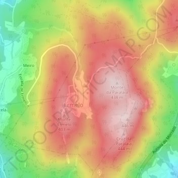
Name: Ermelo topographic map, elevation, terrain.
Location: Ermelo, Bueu, O Morrazo, Pontevedra, Galice, Espagne (42.29271 -8.77483 42.31789 -8.74983)
Average elevation: 298 m
Minimum elevation: 108 m
Maximum elevation: 437 m
Other topographic maps
Click on a map to view its topography, its elevation and its terrain.
O Facho de Donón
Espagne > Galice > O Morrazo > Cangas
O Facho de Donón, Cangas, O Morrazo, Pontevedra, Galice, 36948, Espagne
Average elevation: 49 m
Parque Nacional Marítimo Terrestre das Illas Atlánticas de Galicia
Parque Nacional Marítimo Terrestre das Illas Atlánticas de Galicia, A Illa de Ons, Bueu, O Morrazo, Pontevedra, Galice, Espagne
Average elevation: 47 m