
Two Rivers topographic map
Interactive map
Click on the map to display elevation.
About this map
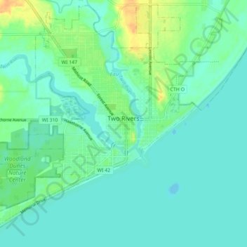
Name: Two Rivers topographic map, elevation, terrain.
Average elevation: 180 m
Minimum elevation: 172 m
Maximum elevation: 200 m
Other topographic maps
Click on a map to view its topography, its elevation and its terrain.
Maribel
États-Unis d'Amérique > Wisconsin > Manitowoc County > Maribel
Maribel, Manitowoc County, Wisconsin, 54227, États-Unis d'Amérique
Average elevation: 259 m