Geolocate

Sumerpur topographic map

Click on the map to display elevation.

About this map

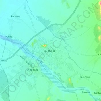
Name: Sumerpur topographic map, elevation, terrain.

Location: Sumerpur, Sumerpur Tehsil, Pali, Rajasthan, 306902, India (25.11381 73.04165 25.19381 73.12165)

Average elevation: 273 m

Minimum elevation: 253 m

Maximum elevation: 381 m

Other topographic maps

Click on a map to view its topography, its elevation and its terrain.

Jawai Dam

India > Rajasthan > Sumerpur Tehsil

Average elevation: 320 m

Jawai

India > Rajasthan > Sumerpur Tehsil

Average elevation: 302 m

Gear up for your next adventure:

🛌Sleeping Mats - Insulated mats for comfortable outdoor sleeping
Camping Shelters - Emergency and lightweight shelters for outdoor use
🎒Replacement Sternum Straps - Repair parts for hiking rucksacks
🔦Head Torches - Hands-free lighting for hiking and camping
🎒Hiking Backpacks - Comfortable backpacks for day hikes and multi-day treks

As an Amazon Associate, this site earns from qualifying purchases at no extra cost to you.